Theme: Coastal Systems I
4:00 Ava Kreider-Mueller – Dartmouth – Title: A combined Ti(III)-Azide reducing reagent for the chemical conversion of nitrates to N2O for d15N isotopic analysis
Author(s): Ava Kreider-Mueller & Mark A. Altabet
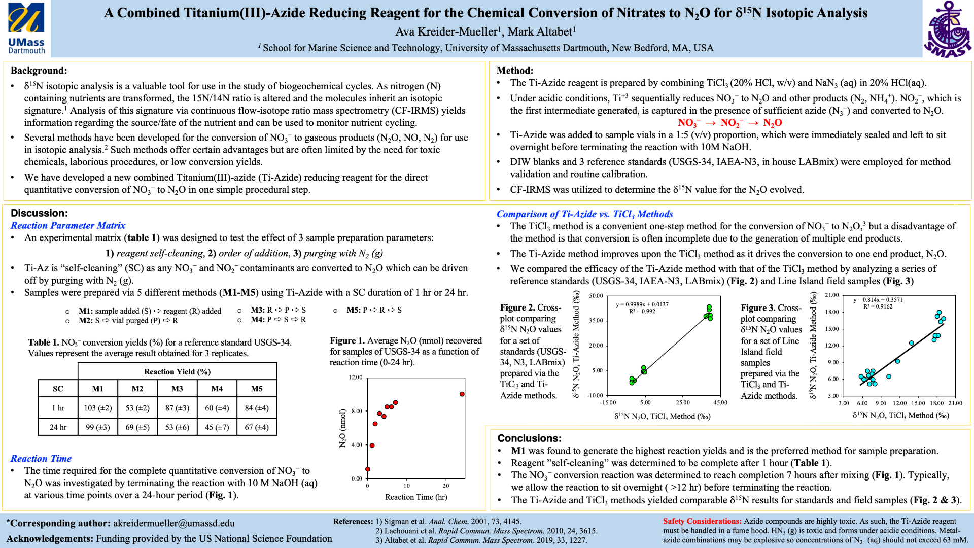
d15N isotopic analysis, which can be used to identify the sources and monitor the fate of nitrate (NO3–) in ecosystems, has proven to be an effective tool for use in the study of terrestrial and marine nitrogen cycles. Although there are several well established methods designed to reduce environmental NO3– to nitrous oxide (N2O) for analysis by continuous flow-isotope ratio mass spectrometry (CF-IRMS), such methods typically require the use of toxic chemicals, involve arduous laboratory preparations, or result in the production of multiple end products that lower the reaction yield. We developed a new, combined Titanium(III)-Azide (Ti-Azide) reducing reagent for the quantitative conversion of NO3– to N2O, which is accomplished in one procedural step with reproducible reaction yields and reliably accurate d15N measurements. The reagent is easily prepared from inexpensive chemical components, and samples can be prepared within a few minutes. Herein we describe the results of a time-series test and an experimental matrix that were designed to identify the optimal method of sample preparation that ensures the most reproducible d15N measurements and highest yields are obtained. To test the validity of the new method, we prepared a set of Line Island water samples using the Ti-Azide method as well as the previously established TiCl3 method and found that IRMS analysis gave comparable d15N results.
4:15 Jessica Thomas – Dartmouth – Title: Micro-siting and Nitrogen Removal Efficiency of a Liquid Injection Permeable Reactive Barrier (PRB)
Author(s): Jessica Thomas, Dr. Brian Howes, and Dr. Miles Sundermeyer
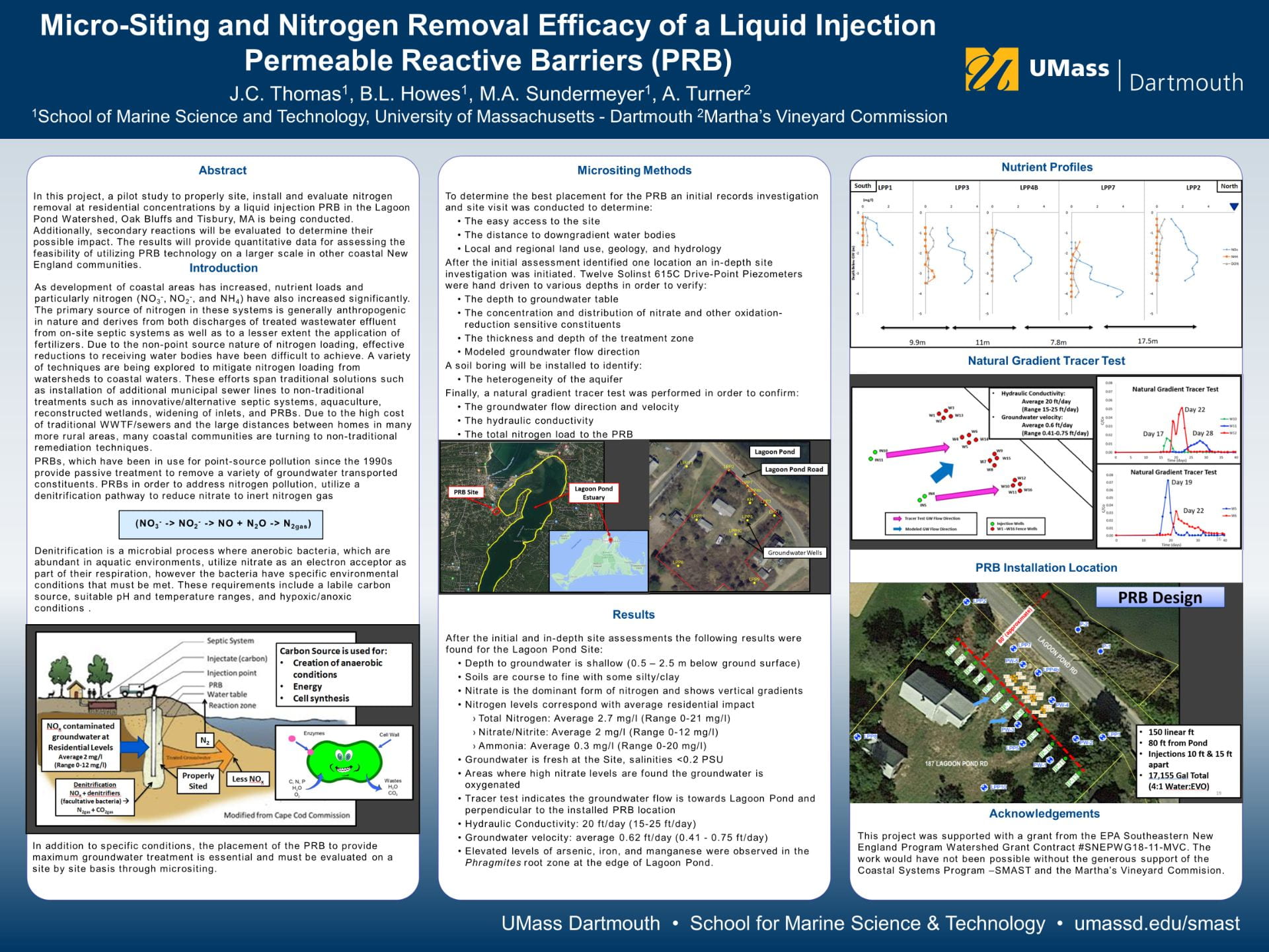
Development of coastal watersheds has led to an increase in nitrogen loads to adjacent waters. In addition to known health impacts nitrogen (as nitrate) can have on people, receiving waters are much more sensitive and can become severely impacted. Nitrogen mitigation efforts span from traditional to non-traditional treatments. Due to high costs of traditional WWTF/sewers and distances between homes in rural areas, many coastal communities are investigating non-traditional techniques such as liquid injection Permeable Reactive Barrier (PRB).
My/our research investigates the utility of liquid injection PRBs as a remediation tool for the reduction of groundwater transported nitrogen from residential areas to estuaries. To be effective, PRB technologies must be specifically tailored for local site conditions. Investigations will establish how micro-siting techniques influence PRB installation and design to maximize reduction of nitrogen per unit cost. Post-installation monitoring will determine the amount of nitrogen reduction that is achieved in groundwater from residential areas. To understand the longevity of liquid injection PRBs the extent to which the PRB injectate (emulsified vegetable oil (EVO)), travels with groundwater, spreads from point of injection, remains active supporting denitrification, and the rate of oxidation of the EVO will be determined. Additionally, secondary reactions that occur will be monitored to evaluate their impact to groundwater and receiving waters. Finally, it will be determined to what extent PRBs can be utilized as part of an integrated remediation effort to meet regulatory nitrogen thresholds to restore/maintain estuarine habitats with significant residential levels of groundwater nitrogen enrichment.
4:30 Shannon Hogan- Boston – Title: Microplastic Pollution on Nantucket Island
Author(s): Shannon Hogan & Dr. Juanita Urban-Rich
The study of microplastics in the environment is crucial to understanding further impacts of plastic pollution. It is known that microplastic pollution is widespread in the marine ecosystem from two main contributors: primary sources those of which produce polymers as the building blocks of other materials (clothing, exfoliators, etc.), and secondary sources which result from the breakdown of large plastic debris (Guerranti et al., 2019). Once broken down these microplastics disperse throughout the oceans by surface transport or bottom water transport. While these microplastics are carried to deeper waters or other regions of the ocean, they interact with environmental contaminants and pollutants which have the potential to bind to the plastic polymers (Hartmann et al., 2017). These microplastics are then ingested by marine organisms from all different trophic levels including zooplankton, suspension feeders and marine mammals. Once digested, the bound pollutants become bioavailable in the organism leading to harmful impacts (Botterell et al., 2019).
My specific research will study microplastic pollution in the marine environment of Nantucket Island, located off the coast of Cape Cod, Massachusetts. Microplastic levels will be determined in sand, seawater and suspension feeder samples from Nantucket Harbor, Madaket Beach, and Surfside beach. Additionally, microplastic levels will be studied in seal scat collected from Great Point in the Coskata-Coatue Wildlife Refuge. The data discovered will be used to create a baseline of microplastic pollution levels on Nantucket Island to be utilized for future analysis. Furthermore, this knowledge and information will be shared through public outreach and education.

Theme: Fisheries I
4:00 Tabitha Breault – Dartmouth – Title: Spatial overlap between sand lance and Atlantic cod in Stellwagen Bank National Marine Sanctuary
Author(s): Tabitha Breault1, Tammy Silva1,2 Travis Lowery1, Nicholas Calabrese1, Kevin Stokebury1, Gavin Fay1
Forage fish play important roles in marine ecosystems and their abundance and distribution can have major impacts on predators, including commercial fishes. Understanding how forage fish influence the distribution of commercial fish species can be an important component of management. We used video data from the SMAST Video Trawl Survey to document spatial relationships between sand lance and Atlantic cod, a key prey species and an important commercial fish species, in Stellwagen Bank National Marine Sanctuary. Sand lance were counted in 14 tows from the Spring 2017 survey using video annotation software. Counts of sand lance and cod (existing data) were used to quantify spatial overlap at two scales (regional and local) using two spatial metrics, the global and local Index of collocation. At the regional scale, sampled sand lance and cod populations showed almost complete separation. However, when focusing on a smaller area of the sanctuary known to be an important cod spawning area, overlap was higher. These results suggest that the distribution of Atlantic cod is influenced by other factors in addition to prey and provides valuable insight for spatial management of both cod and sand lance.

4:15 Mike Coute – Dartmouth- Title: The Impact of Feeding Frequency on the Food Consumption of Juvenile Tautog (Tautoga onitis) in Recirculating Aquaculture Systems
Author(s): Michael Coute & Dr. Pingguo He
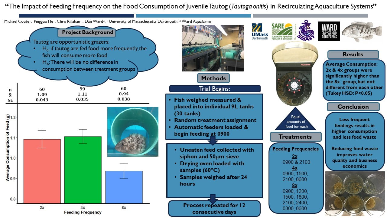
Tautog are a valuable commercial and recreational finfish species in southern New England coastal waters, but high demand has led to depleted populations. To counter this decline, tautog have been identified as an ideal candidate for finfish aquaculture. The aquaculture community continually seeks out new and efficient feed delivery techniques. We incorporate tautog feeding behavior into culture methods through a focus on how and when the feed is distributed to individual fish. Fish were fed the same weight(g) of commercial pellets at different intervals throughout the day and night. Our results revealed that some fish could consume 2% of their body weight during the night, contrary to the previous assumption that tautog fed exclusively during the day. On average, fish fed two and four times per day ate significantly more than fish fed eight times per day (ANOVA: P<0.05). Our results led to a rejection of our hypothesis and our null hypothesis. The highest feeding frequency resulted in the lowest average consumption. The effects of different feeding frequencies provided insight into the preferred eating regime of individual juvenile tautog. We have concluded that by using practices that incorporate individual feeding patterns, regional aquaculture farmers can develop cost efficient strategies for feed delivery that improves fish welfare.
4:30 Alison Frey -Dartmouth – Title: Assessing potential impacts of offshore wind development on Southern New England cod
Author(s): Alison Frey, Gregory DeCelles, Sofie Van Parijs, Christopher McGuire, Matt Camisa, Steven Cadrin
Atlantic Cod (Gadus morhua) is an ecologically, economically, and culturally important groundfish species in the Northwestern Atlantic Ocean. This species has been historically overexploited, and New England stocks remain well below rebuilding targets due to overfishing, poor recruitment, and climate effects. Spawning dynamics and stock structure of cod is relatively uncertain in the southernmost extent of their range, Southern New England, where offshore wind development is planned on cod spawning grounds. Spawning aggregations have previously been shown to be highly sensitive to human disturbance. This study aims to map the spatiotemporal distribution of cod spawning in Southern New England while serving as a pre-construction baseline study for characterizing interactions of cod with planned offshore wind development. Beginning in November 2019, in collaboration with commercial and recreational fishermen, we tagged spawning cod with acoustic transmitters and deployed an acoustic array with ten moored receivers, accompanied by a receiver reporting in real-time attached to an autonomous glider. Data from three subsequent seasons will help to quantify residence, straying, arrival, departure, and fidelity to the Cox Ledge spawning ground. Fisheries-dependent biological samples will also be used to characterize the spatiotemporal distribution of spawning. Preliminary results from the first two years of tagging and biological sampling suggest spawning occurs from November to March, with high residence in the Cox Ledge area, some regional distribution outside Cox Ledge, and evidence of spawning site fidelity. Results from this study will indicate the spawning dynamics, habitat use, and help to inform the stock structure of Atlantic Cod.

Theme: Physical Oceanography I
4:00 Caique Dias Luko – Dartmouth – Title: Revisiting the South Equatorial Current
Author(s): C. D. Luko, I. C. A. da Silveira, I. T. Simoes-Sousa, J. M. Araujo, A. Tandon and G. R. Flierl
The southern branch of the South Equatorial Current (SSEC) is the northern limit of the South Atlantic Subtropical Gyre. When this current reaches Brazil around 14◦S it bifurcates into a southward flow as the Brazil Current (BC) and the surface portion of the northward flowing North Brazil Undercurrent (NBUC). The SSEC system is a key component of the western boundary supply, influencing on the NBUC/BC variability and, therefore, on global climate through the Meridional Overturning Circulation. In this study, using altimetry satellite data and reanalyses outputs (1993-2018), we revisit the SSEC mean state and show this current arriving at the South Atlantic western boundary as a multi-banded jet with surface signatures resulting from different subsurface cores. These bands have velocities between 0.02 and 0.07 m s⁻¹. In addition, the SSEC annual cycle analysis shows that the seasonality of the bands is out of phase with each other, presenting westward transport anomalies between 0.4 and 2.6Sv. Finally, our results show that the seasonality of this multi-banded jet both defines where the BC is born and modulates the seasonality of semi-permanent mesoscale eddies off Brazil.

4:15 Siddhant Kerhalkar – Dartmouth – Title: High Resolution Observations of Diurnal Warm Layers in the Bay of Bengal during the Indian Summer Monsoon 2019
Author(s): Siddhant Kerhalkar 1*, Amit Tandon 1, J. Thomas Farrar 2 , Verena Hormann 3, Luca Raffaele Centurioni 3, Andrew J Lucas 3
1University of Massachusetts Dartmouth, 2 Woods Hole Oceanographic Inst, 3Scripps Institution of Oceanography
Intraseasonal oscillations during the Monsoon seasons in the Bay of Bengal has different characteristics in terms of meteorological conditions as well as in the upper ocean structure with varying behaviors for timescales as short as a diurnal scale. These variations can lead to different air-sea coupling configurations. We make use of meteorological measurements and surface and upper ocean profiling from Air-Sea Flux profilers as well as drifters spread across a mesoscale length. This gives us a spatial view of the intraseasonal oscillations in the Bay of Bengal during the field campaign of MISOBOB (an ONR funded DRI) in July 2019. The first 10 days of the field campaign can be characterized by a 0.3-0.4 K amplitude of SST within a diel cycle. This was followed by 5 days of intense diel cycles (of about 1 K or more) before observing a suppression in the diel cycles in SST and a net cooling trend throughout the bay. Such intense diel cycles show the very strong coupling between the atmospheric variables and the upper ocean temperature structure. The intense diel cycles also lead to the formation of Diurnal Warm Layers (DWL). DWL, in presence of a salinity governed stratification which is common in the Bay of Bengal, could also lead to sub-surface warm layers. The formation and evolution of Diurnal Warm layers within a diel cycle in the Bay of Bengal is studied here using the observations and models and discussions about resolving these processes could lead to better predictions.
Theme: Advances in Ocean Technology
4:00 Aleks Bourgoun – Dartmouth – Title: Characterization of optimal surface geometry to enhance lifetime of underwater super-hydrophobic surfaces
Author(s): Aleks Bourgoun & Dr. Hangjian Ling
Nano/microscopically textured Super-Hydrophobic Surfaces (SHS’s), which trap air bubbles within their textured surfaces, have many useful engineering applications. Unfortunately, SHS’s suffer from short lifespans, lowering their usability and commercial appeal. One of the key factors that determines SHS lifetime, is the diffusion length, a relatively poorly studied component of gas diffusion which is critical in estimating the lifetime of an SHS. This study intends to better understand what factors influence diffusion, and if there is an accurate way to determine diffusion rate theoretically. Numerical simulation is performed to study the gas diffusion for a SHS with groove geometry. The impact of the groove dimensions, including groove width, groove wavelength, groove height, on the gas diffusion rate and lifetime of SHS were studied. To further validate the simulation, a series of experiments were conducted to measure the gas diffusion rate based on bright-field microscopy as well as reflective interference contrast microscopy.

4:15 Patrick Pasteris – Dartmouth – Title: Aurelia Project: A low-cost buoyancy vehicle for upper ocean data
Author(s): Mr. Patrick Pasteris, University of Massachusetts Dartmouth Department of Mechanical Engineering
Advisor: Dr. Amit Tandon, University of Massachusetts Dartmouth Department of Mechanical Engineering
The primary goal of this research is to develop lightweight, low-cost and easy to operate upper ocean profilers which can quickly and reliably be adapted to fit the specific needs of the user. The energy budget of the ocean sets the stage for global weather patterns creating a need for large scale oceanic observation systems. There are programs, such as the Global Drifter Program and the Air-Sea Interaction Regional Initiative in the Northern Indian Ocean, which aim to deliver oceanic data at a high enough resolution to feed quality data into models which will improve weather prediction and ocean health monitoring. In addition to remote sensing technology, a large array of devices is deployed to take direct measurements of surface and subsurface data. The cost of these devices effects the ability to obtain a higher resolution of observations throughout the ocean. The proposed device, Aurelia, focuses on upper-ocean mechanisms (top 50-200m) allowing use of a simplified buoyancy engine with mostly off-the-shelf components and rapid prototyping to significantly lower the production cost. Aurelia operates by using a syringe pump to regulate its density while monitoring pressure differences in the ocean to determine its depth. The design will include wireless programming and communications, a hull and buoyancy engine designed to be scalable to reach greater depths, and a user-friendly interface.
4:30 Maxwell Shangraw – Dartmouth – Title: Improving Digital Holography to Track 3D Bacterial Motion
Author(s): Maxwell Shangraw & Dr. Hangjian Ling
Our proposed research seeks to study the interaction between bacteria and submerged surfaces in a marine setting, to evaluate the anti biofouling properties of Super hydrophobic surfaces that trap air between the surface and liquid interface. Bacterial swimming characteristics and behavior near solid surfaces are explored through Digital Holographic Microscopy (DHM). Holograms are recorded through experimentation, and reconstructed numerically based on Rayleigh-Sommerfeld diffraction theory. Novel methods are proposed to address the issues of the twin image and depth of focus that plague DHM. The twin image problem is solved by reconstructing and comparing two intensity fields: the scattering field only, and the supposition of scattering and incident fields. The depth of focus problem is solved by measuring particle displacement using the supposition of scattering and incident fields. Since the elongation of particle trace along the optical axis is reduced, the accuracy of depth displacement measurements are improved. We demonstrate our method first by measuring the Brownian motion of 1 um polystyrene spheres in 3D space. Then, we test our method on two types of marine bacteria: vivo bacterial strains UMD1 and V. Cyclitrophicus NCT10V. Our results show promising results to track the 3D motion of bacteria. Future works are still needed to enhance the signal-to-noise ratio of the bacteria in digital holography.
Theme: Remote Sensing / Imaging
4:00 Marceonila Cunha – Dartmouth – Title: Satellite Image Coastal Monitoring
Author(s): Marceonila Marcela Bezerra da Cunha
Coastal studies are essential for socio-environmental development and in decision-making on mitigating environmental impacts such as the intense erosion of sandy beaches in the coastal area of Northeast Brazil. The coastal zone of Rio Grande do Norte (RN) is home to more than half of the state’s population, with fragile ecosystems under intense coastal hydrodynamics, requiring interventions to preserve and minimize the effects on human activities. Pititinga beach, like many others in the Brazilian coast, suffers from the effects of coastal erosion. Thus, implementing a satellite image monitoring is a good way to measure the movement of the coastline. It was implemented a multitemporal analysis from 1973 to 2017 in the area using different intervals and aiming calculating the sedimentary budget and, as a result, maps indicating the erosion and deposition spots. Therefore, from the erosion and deposition maps analysis it was possible to notice that the deposition areas decrease significantly and that the total sedimentary budget, although positive, becomes negative in the last two periods from 2004 to 2014 and 2014 to 2017. Therefore the constant and systematic monitoring of the coastline and its geomorphological features is a very relevante tool for coastal planning and management, providing subsidies for the elaboration of impact mitigation strategies, area recovery and users safety. In addition, it is an accessible resource providing both society and academia with accurate and low-cost results.
4:15 Neeharika Verma – Dartmouth – Title: High Resolution Characterization of Phytoplankton Community Composition in a Large River-Influenced Coastal Margin Using Underway Hyperspectral Remote Sensing Reflectance
Author(s): Neeharika Verma & Dr. Steven Lohrenz
High inflow of freshwater from the Mississippi river into the northern Gulf of Mexico (NGOM) during spring contributes to strong environmental gradients across the river-ocean mixing zone. River inputs generate salinity and nutrient gradients that extend from the shelf to the open ocean and are important factors that influence the composition of phytoplankton communities. Hyperspectral remote sensing reflectance measurements can provide high-resolution information about oceanic constituents that contribute to surface water optical signatures. Light absorption by phytoplankton, a significant contributor to the optical variability, is influenced by cellular pigment composition and the packaging effect, which is in turn influenced by cell size. Given the spectral features that arise due to pigment-specific light absorption, hyperspectral measurements of above water remote sensing reflectance enable us to distinguish phytoplankton pigment absorption features that can be used to infer characteristics of phytoplankton cell size classes (micro-, nano- and pico- phytoplankton) and pigment composition, complementing and extrapolating the scale of in situ sampling and pigment analyses. Here, we examined underway remote sensing reflectance to assess fine-scale variations in phytoplankton optical size indices along environmental gradients of river plume conditions (light and nutrient availability) in the northern Gulf of Mexico. Our findings highlight the transition in phytoplankton community composition from a mixed community of micro- and pico- phytoplankton within the river plume to a primarily microphytoplankton-dominated community beyond the river plume-ocean mixing front.
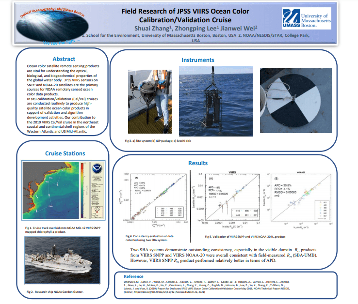
4:30 Shuai Zhang – Boston – Title: Field Research of JPSS VIIRS Ocean Color Calibration/Validation Cruise
Author(s): Shuai Zhang
Ocean color satellite remote sensing products are vital for understanding the optical, biological, and biogeochemical properties of the global water body. JPSS VIIRS sensors on SNPP and NOAA-20 satellites are the primary sources for NOAA remotely sensed ocean color data products. In situ calibration/validation (Cal/Val) cruises are conducted routinely to produce high-quality satellite ocean color products. Summarizing our contribution to the 2019 VIIRS Cal/Val cruise in the northeast coastal and continental shelf regions of the Western Atlantic and US Mid-Atlantic.